The aggregate number of hurricanes continues to amaze me and yet I know from personal experience that, here, we take them in stride. We prepare for them…we watch for them…we track them, and when one hits…we deal with it.
Our latest hurricane of note, Hurricane Isabel in 2003, is a great example. Flooding, downed trees, power outages, roof damage, broken windows…it seems it’s part of living here.
So my final installment is…
Historic Hurricanes! --
Norfolk County Hurricanes From 1901 to Present
1903 – A “Freakish Vagabond Hurricane,” or so it was called, tracked north off the coast of southeast Virginia, but brought winds and rain strong enough to remind residents that the storm was no trifle.
And now for the freakish part…At Fort Monroe, just across the James River from Willoughby Spit in Norfolk County, it…rained…birds. Yes…birds! The birds were swept up and killed by the storm in the Caribbean, and were carried all the way to Hampton Roads. Thousands of dead, half-feathered birds, about the size of a wren, rained on streets and sidewalks, struck windows, and frightened local residents.
A second hurricane tracked closer to shore in October, bringing higher winds, moderate damage, and a storm surge that was 9 feet above mean low tide in Norfolk County. A number of ships ran aground off the coast of Virginia Beach, keeping the U.S. Life-Saving Service busy.
 |
| First Flight |
October 1923 – A storm came dangerously close to shore but provided only moderate coastal flooding and winds of about 56 mph. This one is noteworthy simply due to its longevity. It was one of the longest lasting hurricanes in history.
Many storms form, hang together for a few days, or even a week or so. They fizzle out when they encounter a landmass or when they are hit by upper-level wind shear. This storm formed near South America and tracked north through Cuba and the Bahamas before reaching the Virginia coast...9 days later! Still churning, the storm continued north through Pennsylvania and New York into Canada…but it didn’t stop there! The weather bureau finally stopped tracking the storm when it reached the Arctic Circle!
December 2, 1925 – What about a December Hurricane? That’s what I said…a hurricane…in…December! Right after Thanksgiving, a late -- very late -- season storm developed into a hurricane as it tracked over Florida. By the time it reached Norfolk County on December 2nd , it had diminished in strength to a tropical storm with 60-mph winds. This storm still holds the record for being the latest hurricane to make landfall in the United States.
Before 1925, hurricane season in the United States ended in October. But after 1925, the end of hurricane season was moved to November 30th.
1933 was the busiest year for storms on record with 21 storms. In Norfolk County, back-to-back hurricanes passed through the area, one in August and one in September. The Chesapeake and Potomac Hurricane made landfall in the Outer Banks of North Carolina and tracked northeast through Norfolk County on August 23. Norfolk Naval Air Station recorded gusts of almost 90 mph, and 70-foot waves were reported off the coast.
Flooding was widespread in Virginia Beach, as well as in downtown Norfolk and Portsmouth. A police officer was actually reported directing traffic in his bathing suit!
While the storm deposited 8 inches of rain in Norfolk County, it also caused one of the highest surges in the 20th century. Willoughby Spit was swamped by the surge, ruining houses and businesses along Ocean View. One casualty of the storm was the original Doumar’s at Ocean View Amusement Park. Abe Doumar was the inventor of the ice cream cone. Doumar’s reopened, but moved its location to downtown Norfolk.
 |
| Doumar's at Ocean View |
And that was just the first storm…Still reeling from the Chesapeake and Potomac Hurricane, the area was hit again three weeks later by an even more powerful storm. Landing a direct hit at Cape Hatteras on September 15th, the storm caused the most significant damage in the Outer Banks. Luckily for Norfolk County residents, it turned northeast and away from Norfolk County, leaving less wind damage than at Cape Hatteras. But the damage from flooding was still considerable.
September 5, 1935 -- The Great Labor Day Hurricane of 1935 was the most powerful hurricane to make landfall in the United States. This most decidedly Category 5 storm killed 400 out-of-work WWI veterans in the upper Florida Keys, who were sent to build the Overseas Highway (U.S. Highway 1).
As the storm approached, a train was sent to evacuate the workers and other residents before the storm made landfall, but it arrived at the worst possible time – right at the peak of the storm’s intensity. High winds and an immense storm surge swept the train full of evacuees right off the tracks. To make matters worse, communications were a shambles, holding up rescue and relief efforts.
You can see a short film of the destruction of the Florida Keys from the 1935 hurricane: http://www.youtube.com/watch?v=x1lSVcYM2WE
In Virginia, the storm is known as the Flood of ’35. The torrential rains caused the James River to flood, and the storm spawned tornadoes for two days. One tornado touched down in Norfolk County in the afternoon, killing three people.
September 17, 1936 – A Category 2 hurricane came within 25 miles of Virginia Beach and brought 84-mph winds, almost canceling Norfolk’s bicentennial celebration. The tide peaked at the second highest level in a century (the highest was during the storm of 1933). After the storm, the Weather Bureau took pride in its successful warning of the impending storm and its ability to minimize loss of life and property.
September 14, 1944 -- A hurricane passed within 45 miles of Norfolk County. The Weather Bureau, in an effort to warn the public of the impending storm, called it the Great Atlantic Hurricane.
On its way from the Bahamas toward the Outer Banks of North Carolina, the storm capsized a Navy destroyer, a minesweeper, and two Coast Cutters. Analysis suggests that the storm was a very strong Category 4 or Category 5 hurricane. Cape Henry clocked 134-mph winds and gusts as high as 150 mph.
Starting in 1953, the Weather Bureau began naming hurricanes…with women’s names. The bureau added men’s names to the list in 1979. Naming storms made it easier to distinguish between storms when reporting to the public, especially when multiple storms were tracking simultaneously.
August 14, 1953 – Hurricane Barbara made landfall in the Outer Banks of North Carolina with hurricane force winds and torrential rains. In the Outer Banks, a man was killed when he was swept off a pier by high surf. In Norfolk County, police officer Talbot Barrow was killed while on duty when he was electrocuted by submerged power lines that were downed by the storm. He was 42 years old.
 |
| Officer Talbot Barrow |
Déjà vu! -- Again in 1955, three hurricanes struck Virginia – Connie, Diane, and Ione.
September 13, 1960 – Hurricane Donna, a major storm, after passing through Florida, tracked north-northeast and made landfall again in the Outer Banks of North Carolina. In Norfolk County, winds reached 75 mph and gusts were as high as 90 mph. But on the Chesapeake Lightship moored almost 20 miles offshore, gusts were recorded as high as 138 mph. Three people were killed in the storm, and property damage was significant, with power being out for days after Hurricane Donna passed.
September 1964 – Now incorporated as the city of Chesapeake, Norfolk County was awash with back-to-back hurricanes in 1964 – Cleo and Dora. Both dropped a load of rain on the area, making it the wettest September in history with over 12 inches of rain.
September 11, 1967 – Hurricane Doria “blew in a wet kiss of death” to the city of Chesapeake’s first fair. The storm passed to the east of Hampton Roads off shore but dumped rain on the fairgrounds, creating a muddy mess and delaying the opening of the week-long celebration. After her first pass, the skies cleared and the fair opened. Then, “Dipsy Doria,” so she was called by the Chesapeake Post newspaper, looped around and headed back toward Hampton Roads a second time, closing the fair prematurely.
During the fair’s short duration, the Norfolk County Historical Society selected the winning entry for “Finest Historical Painting of a Chesapeake Scene” a painting of historic Oak Grove Methodist Church by Ernest Brownley. It now hangs in the Wallace Room. Here’s a timeline of Oak Grove Church’s history:
http://www.oakgroveumc.com/templates/System/details.asp?id=25911&PID=435766
August 20,1969 – Hurricane Camille exited…yes, exited…the United States over Hampton Roads. Normally, hurricanes make landfall here, but Camille did things her own way…in a big way.
After making landfall in the Gulf Coast on August 17th with 200-mph gusts, Camille barreled through Mississippi and Tennessee killing 140 people. She then made a sharp turn toward the east and drenched Kentucky. On her way back out to sea, she dumped 30 inches of rain – over 5 inches of rain per hour -- in Nelson County, Virginia, southwest of Charlottesville, Virginia. All that rain caused incredible flooding and disastrous mudslides, killing over 150 people in Virginia.
In Hampton Roads, downed trees and power outages were Camille’s parting shot as she followed the James River back out to sea. Swollen rivers in the western mountains of Virginia empty to the east into the Chesapeake Bay, and so Hampton Roads watched with awe and waited for the enormous amount of water to spill over riverbanks closer to home.
Google “Hurricane Camille” and you will find dozens of web sites and articles about the devastation she left in her wake.
June 21, 1972 – Hurricane Agnes made landfall in Florida and then crawled up the east coast through the Outer Banks and Hampton Roads. Her slow moment meant lots of rain in Virginia…only 3 years after Camille. The James River crested at over 36 feet and Richmond, Virginia’s capital, was flooded for days without potable water.
For Hampton Roads, Hurricane Agnes made her mark, but in areas north of here, her name is synonymous with the word “disaster.” Agnes went back out to sea at Hampton Roads but continued to dump rain as she tracked north, and then…she turned due west…yes west…through Delaware and Pennsylvania, where rainfall shattered records and towns flooded along rivers in Maryland, Pennsylvania, New York, and Delaware.
Like Camille, Hurricane Agnes, will be well remembered as one of the worst flooding disasters in history. For more information and some pretty awesome images, Google “Hurricane Agnes.”
September 27, 1985 – Hampton Roads was blessed with a near miss when Hurricane Gloria made a glancing blow off the Outer Banks, North Carolina. As residents boarded windows and prepared for Gloria’s worst, local rock radio stations played the 1966 Van Morrison song performed by the band Shadows of Night in an effort to make light of a very worrisome storm. You could hear, “G-L-O-R-I-A! GLO-RI-A!”
Hurricane Gloria, a Category 4 storm, was called the “killer storm of the century” by the local media, but she weakened as she approached land and after her eye passed over Cape Hatteras. By the time she brushed Hampton Roads to the east, she was a Category 1 storm. Damage was limited to downed trees and fences, minor local flooding, and power loss for no more than a day for most.
A Chesapeake Post editorial “Sic transit Gloria” reminded residents that the near-miss should be considered a “practice drill” for the big one.
1996 – Hurricane Bertha on July 13th and Hurricane Fran on September 6th both made landfall in North Carolina, and dumped rain on southeast of Virginia. “Big Bertha” spawned a number of tornadoes in southeast Virginia -- none in Chesapeake – and left part of Hampton Roads without power for a short period -- an inconvenience, but certainly no crisis.
“Fearless Fran” was a powerful Category 1 hurricane when she made landfall, but was quickly downgraded to a tropical storm by the time she crossed into Virginia. Fran also left one of the largest power outages in the history of the state of Virginia, but she left more damage north of Hampton Roads.
July 24, 1997 – Hurricane Danny, the only hurricane to make landfall in 1997, wasn’t a particularly strong storm for this area, but Danny spawned a number of tornadoes. Hurricane Danny actually made landfall in Louisiana and traversed the southeast to exit over Hampton Roads. As a parting shot, Hurricane Danny produced several tornadoes in Chesapeake and Norfolk, damaging a car wash and a lumberyard, and throwing debris everywhere.
Here's weather animation of Hurricane Danny spawning tornadoes: http://cimss.ssec.wisc.edu/goes/misc/danny_ir_anim.html
September 16, 1999 – Hurricane Floyd was a Category 1 hurricane by the time the eye passed over Chesapeake, Virginia, but Floyd was a scary Category 4 before making landfall at the state line between South and North Carolina. This storm dumped over a foot of rain on top of an already saturated Hampton Roads from Hurricane Dennis a few weeks earlier. Rivers in Virginia and North Carolina reached their 500-year flood levels by the time it was all over.
June 16, 2001 – While Tropical Storm Allison wasn’t a huge storm in Virginia, it was one of the most destructive storms in American history. I lived in Houston when Allison drifted over Houston toward San Antonio and then back over Houston, delivering over 2 feet of rain in my neighborhood overnight. Yes, I said…2 FEET…of rain in a single night!
Amazingly, Tropical Storm Allison then took over a week to amble across the southeast and then drift a while longer over eastern North Carolina and Hampton Roads, dumping rain all along the way and spawning several tornadoes.
September 18, 2003 – Our most recent storm of significance, Hurricane Isabel, made landfall in North Carolina as a strong Category 2 storm…and we were actually somewhat relieved that she was only a Category 2! Hurricane Isabel had been a monster Category 5 storm, but the cooler waters off the Carolina coast took some of the fight out of her by the time she made landfall in North Carolina.
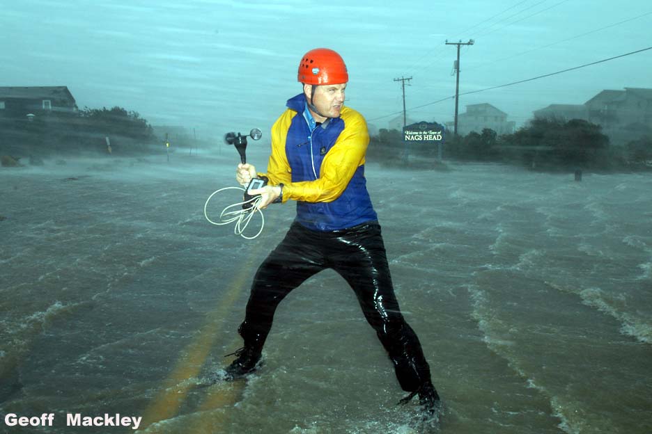 |
| Measuring Isabel's Windspeed Photo by Geoff Mackley |
The storm surge also broke through the Midtown Tunnel floodgates in Portsmouth, closing the tunnel for a month. Flooding, downed trees, power outages, debris all over the streets…Hurricane Isabel was a messy, messy storm…and she left us here to clean up.
We’ve had a few brushes with storms since 2003, but we’ve been lucky that none have been significant…some might be considered menacing, but caused minor damage and localized flooding.
As the 2010 Hurricane Season comes to a close in Hampton Roads, we will continue to keep our fingers crossed and our eyes on the Weather Channel for the next month or so when Hurricane Season officially ends. And next year, we will do it all over again.
So we finish this discussion of Great Gusts! of the 17th and 18th centuries, Terrible Tempests! of the 19th century, and Historic Hurricanes! of the 20th century to the present.
May we be fortunate enough to avoid having to update this list anytime soon.
No comments:
Post a Comment